Editor’s note: Dave Boyles submitted several Cameron, LA, photographs of the aftermath of Hurricane Laura. The first shows a pleasure boat that landed far from its home. Corrections have been made to the text.
 James “Dave” Boyles of Morrison, IL, left town on Friday, August 28, 2020, to offer support to victims of Hurricane Laura in southwest Louisiana. The Category-4 storm winds and “a little over 11-foot storm surge” made landfall early on Thursday, August 27. As an experienced ARC volunteer, Boyles is highly skilled. His task is to organize disaster assessments, which offer appropriate aid to victims, in the most-extreme of conditions, at quickly as possible.
He wrote in a previous article, “After hurricane Laura made landfall, the requests for American Red Cross responders started. One of the earlier groups to be deployed are volunteers to officially assess the damage to homes. I am a Damage Assessment Supervisor, and, within hours, I was assigned. As soon as the Baton Rouge airport was re-opened, I made my flight arrangements….Within 24 hours I am on my way to be a part of the Red Cross immediate recovery efforts.
“Baton Rouge, LA, is a staging area where the headquarters is set up….My assumption is that tomorrow, [Saturday, August 29,] I will be sent out to a District Office to start damage assessments, street-by-street and home-by-home.” Below is what he saw.


He had explained, “We do not know if we will be sleeping in tents, on cots in a gym, in a church basement, barracks, dorm room, or motel room. We relocate from one area to the next during the deployment.” Each day, volunteers drive to their work areas via rental cars. His second headquarters was inside an airline hanger. Boyles was there for a little over a week.
“In addition, they caution[ed] that wildlife may be displaced due to flood waters, with the most common threats being alligators, snakes, mosquitoes, ticks, and fire ants.” Once on the ground Florida National Guardsmen warned of Cottonmouth snakes. One was killed crossing the road by Boyles. While traveling, this displaced Alligator also was photographed along the road.
Bulldozers are moving lots of mud; one home had two feet of mud inside. Below left, a trailer slab, minus someone’s dwelling, displayed an American flag and a statue of the Blessed Virgin Mary. A steel grid on the right shows where the Post Office once lay. “Hurricane straps held the frame,” explained Boyles, “but the rest [of the building] was blown away.”


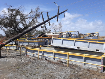
Cemetery vault covers were shifted, but they likely remained near a loved-one’s remains. Twisted oil tanks lay crumpled near where an electrical linesman had begun repairs to downed transformers.


Sunday, September 6, was a group day off, with a planned swamp tour. The destination was Baton Rouge. Travel on Interstate 10 was perilous, due to heavy traffic, erratic driving, and daily accidents. Where were people going, as they evacuated destruction worse than Hurricane Rita? A Coroner replied that one person simply stated, “We’re just leaving.”
Category-5 Tropical Storm Rita was the most intense tropical cyclone on record. It lasted from September 18 to September 26, 2005, with 120 souls dead. That storm affected Illinois, Florida, and Texas; islands in The Bahamas, Cuba, Hispanola, and Turks and Caicos; Europe. The highest wind speed registered 177 mph.
To make matters worse, on Labor Day, Monday, September 7, an eastern Atlantic Ocean storm depression intensified into Tropical Storm Paulette. It became the 16th named storm in a record-breaking hurricane season. Forecasters are watching a tropical depression that formed off western Africa on the same day. It, too, is expcted to strengthen into a Tropical Storm late Monday night.